
Your comments are needed on the Draft Environmental Assessment (EA) for a new development within the riparian area of South Fork, Cave Creek Canyon. Comments on the Draft EA are due very soon, by SEPTEMBER 28, 2020. (The 26th falls on a Saturday.)
Chiricahua Regional Council’s primary goal is to protect valuable intact habitats in the Chiricahua Ecosystem Management Area and adjacent Peloncillo Mountains. CRC is taking the lead in opposing most of this plan's features except for a vault toilet. All other development can better be created elsewhere in Cave Creek Canyon, without causing habitat fragmentation in South Fork.
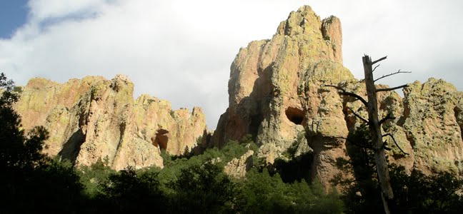
Why South Fork needs protection:
- Uniquely picturesque and world-renowned for its biodiversity
- Designated a Zoological-Botanical Area by the US Forest Service
- Included within a second, special Birds of Prey Zoological-Botanical Area
- Major component of the global-priority Chiricahua Important Bird Area, designated by National Audubon Society
- Stronghold for rare and local species, including Elegant Trogon, recent Eared Quetzal, Montezuma Quail, Whiskered Screech-Owl, Mexican Spotted Owl, Peregrine Falcon, Zone-tailed Hawk, Sulphur-bellied Flycatcher, Ringtail, Mountain Lion, Black Bear, many lizards and snakes
- Designated area of high connectivity for Jaguar [critical habitat now being litigated]
- Species-rich riparian habitat includes Apache Pine, Chihuahua Pine, Arizona Sycamore, Arizona Cypress, Bigtooth Maple, and diverse southwestern oaks
- Both Cave Creek and South Fork are protected as Outstanding Arizona Waters


What is proposed:
1. A new 9-car parking lot, a toilet, a day-use area with picnic tables, a staging area for classes and other groups, and a handicapped-access trail, all within the canyon bottom, with its fragile riparian habitat
2. Facility development proposed for South Fork is new, not a “replacement” as it is called in the EA, because it is planned for a site without previous development
Why oppose the new proposal?
- Serious inadequacies in the draft EA, which offers only 2 options, both flawed: Plan A––no action; and Plan B––develop the full proposal
- With only two options, the CRC must vote for No Action, even though that plan calls for no toilet, resulting in pollution
- New development moves general recreation into an area identified by USFS as having exceptional natural values
- New development located in the heart of a critical Protected Activity Center (PAC) for a pair of Mexican Spotted Owls
- Proposal needs a full Environmental Impact Statement because of expected negative impacts on the Federally-endangered Mexican Spotted Owl
- Fragmentation of habitat within South Fork’s limited canyon bottom
- Degradation of the natural values that the ZBA was created to protect
- "Multiple use" doesn't mean every use, everywhere
- New picnic area invites boom boxes, car stereos and noise into a ZBA where recording equipment is prohibited
- Rucker Canyon to the south has much greater need for facility improvement than the already-developed Cave Creek Canyon

- Extend the comment period, which is too short
- Pause development plans for South Fork and instead develop a consensus plan that guides management of the entire Cave Creek Canyon system
- We fully support placing a toilet in South Fork, but not at the proposed site
- The National Parks Service has developed functional, handicapped-accessible porta-potty housing for floodplain locations, where the toilet can be easily removed if fire or flood threatens; the Forest Service could adapt that design for a removable toilet in South Fork
- Even at the proposed toilet site, a raised pad will be needed to elevate the toilet above the floodplain
- With either the new design or a higher pad, a toilet could be returned to the heavily used parking area at the berm
- Placement at the proposed site degrades habitat within the Spotted Owl PAC
- We fully support bringing small groups of well-supervised school children from the local schools into South Fork, as is currently being done, but we do NOT support the construction of new structures within the canyon for education
- Environmental education is already well handled by the Visitor Information Center and could be augmented by development in an already-used area within the main canyon
- Converting the currently closed Idlewilde Campground to Day Use would incur no new habitat destruction: it already has a vault toilet, tables and ample parking space
- Place dispersed benches along trails and the road in South Fork, for rest, quiet observation, and enjoying snacks or lunch
- Road closure during the high season offers both advantages and disadvantages. Closure would reduce problems with road dust, noise, and traffic hazards to people along the road. We would favor either no closure or a “soft” closure from mid-March through May 30: close the gate but leave it unlocked; install a sign saying that access is open to cabin owners, seniors above a certain age, and handicapped or infirm visitors. At least some of these hazards could also be dealt with by measures such as water bars and stricter enforcement of very low speed limits on the South Fork road.
- Is needed, but can be accomplished elsewhere with less impact and habitat destruction
- Proposed new trail in South Fork lies mostly in the floodplain, leading to significant future maintenance costs and, importantly, danger to trail-walkers in the event of a flash flood
- CRC is willing to aid in constructing and financing a handicapped-access trail in a place that is more appropriate and less destructive
How we would modify the proposal:
Education
Day Use
Benches
Road closure
Trail for Handicapped Access
Funding
Money to maintain the new development is not assured beyond the next 10 years.
The EA states that the Forest Service will not provide money to maintain the new development, and that the new development will be demolished if outside sources of money for maintenance (about $10,000 per year) can’t be sustained.
Comments on the draft plan are DUE ON SEPTEMBER 28!!
If you want to be able to comment on the final Environmental Assessment, you must get comments in this week. It’s called ‘having standing’ under the NEPA process, and you’ll need standing to be able to speak out about the final project.
The scoping letter describing the project is here:
https://www.fs.usda.gov/nfs/11558/www/nepa/112219_FSPLT3_4877408.pdf
Send in your own comments here:
https://cara.ecosystem-management.org/Public/CommentInput?Project=56779
You can read others comments in The Reading Room (see sidebar):
https://cara.ecosystem-management.org/Public//ReadingRoom?Project=56779

I enjoyed birding in this beautiful area and want to preserve this ecosystem for future generation
ReplyDelete